Major earthquakes that have occurred in Israel
In the Land of Israel, evidence of powerful earthquakes exists from as early as the Biblical period. The earthquake that occurred in the days of Uzziah, King of Yehudah, is mentioned in several places in the Prophets by the name "the tremor." There is also evidence of a major earthquake during the Second Temple period.
Josephus, in his book The Jewish War, describes an earthquake that occurred in the year 31 before the Common Era, which claimed approximately 30,000 lives: "In the seventh year of Herod's reign, there was an earthquake in the land of the Jews the like of which had never been seen, and the earthquake caused great slaughter among the livestock of the land. Also some thirty thousand people were killed under the collapse of houses, while the army that was encamped under the open sky was not harmed at all in the disaster."
Year 749 "The Shemittah Tremor": A powerful earthquake struck the Jordan Valley. Beit She'an and Hamat Gader were destroyed, and severe damage was inflicted on additional cities throughout the country, particularly in Tiberias, Yerushalayim, Lod and Jericho. The quake was called "the Shemittah tremor" because it is mentioned in piyutim as a tremor that occurred in the Shemittah year.
Year 1033: Another powerful earthquake struck the Jordan Valley. The damage extended from Egypt to Syria. Jericho was destroyed, and severe damage was inflicted on Ramle and Shechem. Buildings were also destroyed in Yerushalayim, Chevron, Gaza and Acre.
The quake claimed approximately 70,000 lives; this is most likely the deadliest earthquake to have occurred on the soil of the Land of Israel. According to reports of severe damage from the Dead Sea to the Kinneret, the earthquake ruptured the entire Jordan Valley fault segment. Historical documentation also showed that the damage pattern was similar to the Shemittah tremor.
Year 1068: Another earthquake, which according to estimates occurred in the Gulf of Eilat or in the Arava. Severe destruction was caused throughout the country, particularly in Ramle and its surroundings. More than 15,000 people were killed. The estimated magnitude of the earthquake was 7.0.
Year 1202: An earthquake with a magnitude of more than 7 in the Galilee Panhandle-Beqaa Valley region. The Ateret fortress on the banks of the Jordan River was displaced 1.6 meters horizontally in this quake. Destruction and severe damage occurred in areas that are now Syria, Lebanon and Israel. More than 30,000 people were killed. Many more died from plague as a result of the flooding of the Nile River.
Year 1546: An earthquake with an estimated magnitude of more than 6 in the Jordan Valley. Severe destruction and hundreds of casualties in Shechem, Jericho, Yerushalayim, Chevron, Gaza, Ramle and Jaffa.
Year 1759: An earthquake with an estimated magnitude of more than 6.5 in the Beqaa Valley. The earthquake created horizontal displacement of the surface, shifting the Ateret fortress on the banks of the Jordan River by half a meter. The tremor was felt in most areas of the Land of Israel, Jordan and Syria, and destruction occurred in Tzfat, Tiberias, Sasa, Gush Chalav, Ein Zeitim, Sejera, Acre and Nazareth. According to various estimates, between 10,000 and 40,000 people were killed.
Year 1837: An earthquake with an estimated magnitude of 6.5 to 7 struck primarily northern Israel and Lebanon. Severe destruction throughout the Galilee, particularly in the population centers of Tzfat, Tiberias, Shechem, Acre, Nazareth and Tyre. Many houses collapsed on their inhabitants. In Tzfat, most of the casualties were due to landslides that occurred as a result of the earthquake.
The magnitude was most likely 6.5 to 7 degrees; the destruction and devastation were intensified by a series of tsunami waves that rose from the Kinneret and struck Tiberias severely. According to reports by the Turkish pasha, the number of casualties in Tzfat was between 1,700 and 1,800, and in Tiberias approximately 600. In total, estimates are that between 5,000 and 7,000 people were killed in the earthquake.
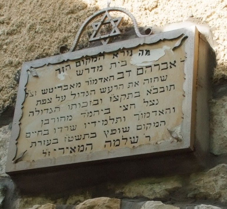
As is known, the holy Rebbe Avraham Dov of Avritch zt"l, the "Bas Ayin," was then in his beis medrash and was davening Minchah. When the tremors began, the Rav instructed all the worshipers to gather around him and prostrate themselves on the ground. The tremors intensified and a large portion of the beis medrash collapsed, but the section where they had all crowded together remained standing and even the roof remained suspended in the air, and the worshipers were saved by a miracle.
A sign in his beis medrash reads: "How awesome is this place, the beis medrash of Rabbi Avraham Dov the Admor of Avritch zt"l, who foresaw the great tremor over Tzfat, may it be rebuilt and established speedily, in 5597 [1837], and by his great merit half the beis medrash was saved from destruction and the Admor and his students survived."