
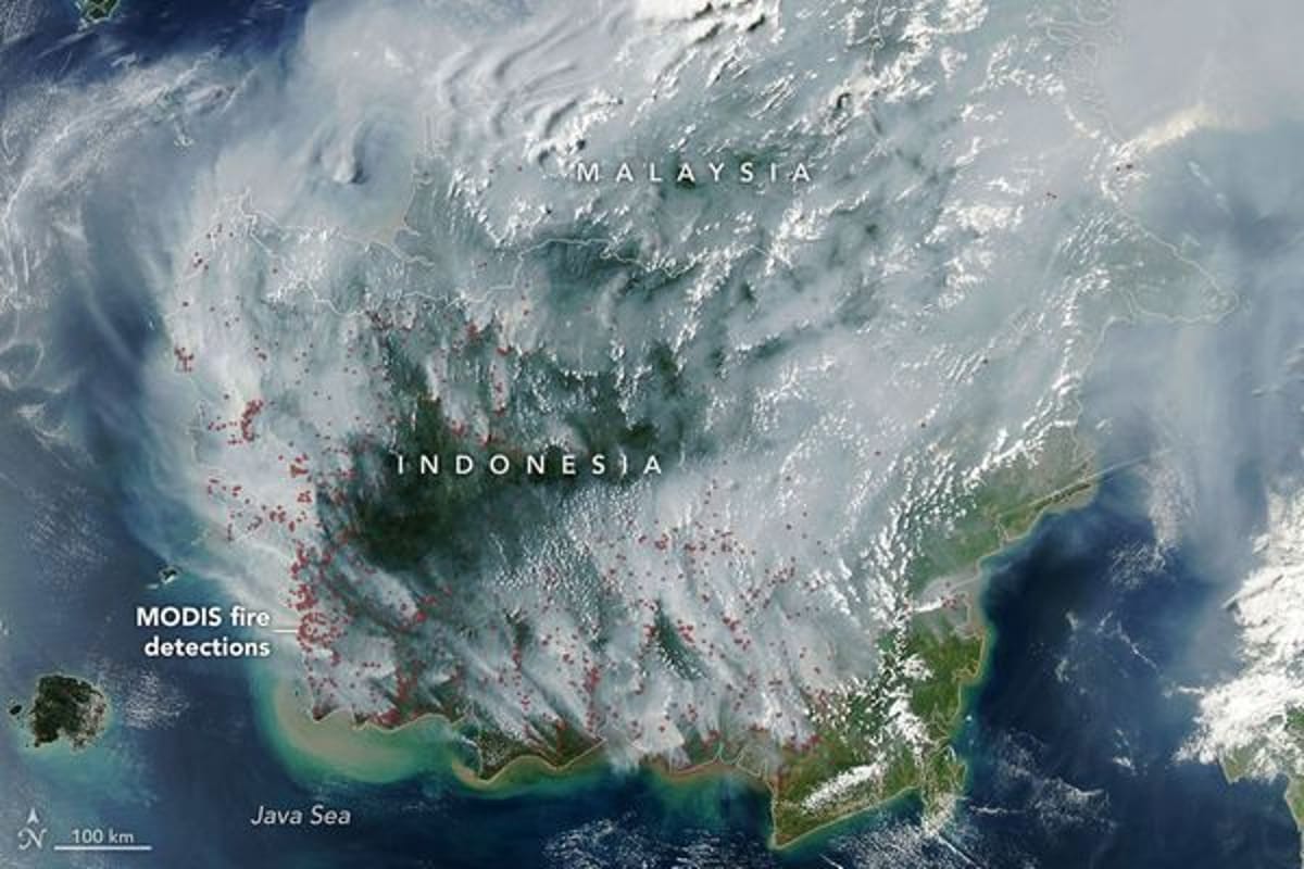
Indonesia's fire season has only just begun, yet scientists are already sounding alarms about an especially dangerous phenomenon: fires that don't merely consume vegetation on the surface but penetrate into peat layers and spread beneath the ground. Unlike typical forest fires, these underground blazes can burn slowly for weeks or even months, continuously releasing smoke and pollutants until the rains return.
These are peat fires, considered among the most stubborn and polluting types of fires on Earth. Peat is organic material formed over many years from accumulated dead vegetation in wet environments. Normally saturated with water and difficult to ignite, peat becomes highly flammable when drought dries it out, capable of burning underground at relatively low temperatures.
The challenge extends beyond the difficulty of extinguishing these fires. According to assessments published by NASA Earth Observatory, peat fires can produce three times more fine particulate matter than other tropical forest fires, five times more sulfur dioxide, three times more organic carbon, and double the amounts of methane and carbon monoxide.
Images captured by NASA's Aqua satellite on September 1 showed that the 2026 fire season is already in full swing. Indonesia holds approximately 36 percent of the world's tropical peatlands, and during severe drought seasons, areas that should remain wet become exceptionally flammable.
This year's concerns are also linked to the strengthening of the El Niño phenomenon. NOAA (the U.S. National Oceanic and Atmospheric Administration) estimated in August that El Niño is already present and intensifying—a pattern that typically reduces rainfall in Indonesia. Simultaneously, a positive phase of the Indian Ocean Dipole has been recorded, which could further exacerbate dryness in the region.
According to Robert Field from Columbia University, fire activity at the season's start is worryingly reminiscent of developments observed in 2015. He noted that while the fire season is in a relatively early stage, the number of fire hotspots is rising rapidly.
The comparison to 2015 is particularly troubling. That year, fires burned for more than three months and led to an estimated release of approximately 1.75 billion tons of greenhouse gases in carbon dioxide equivalent terms. By September 2 this year, the 2026 fires had already released an estimated one-tenth of the amount emitted during the major 2015 crisis.
Drought conditions this year are also exceptional. According to data from Indonesia's meteorological service, by early August approximately 90 percent of the country's area had received very little or no rain at all. Under such conditions, peat layers in regions like Kalimantan, Sumatra, and Papua dry out, allowing fire to penetrate them.
"When fire goes underground, it simply doesn't stop," Field explained. He noted that such fires may continue burning until rains return in October or November.
One paradox of this phenomenon is that even advanced monitoring systems sometimes struggle to detect the most severe fires. Indonesia relies on NASA and NOAA's MODIS and VIIRS satellites to track fire hotspots, and on August 31, the government tracking system recorded 946 hot spots. However, when smoke becomes particularly thick, it can obscure the fire from satellite view. Fires beneath the forest canopy or within peat layers themselves may also evade detection.
The roots of the problem aren't purely climatic. During the 1990s, drainage and irrigation canals were dug in various Indonesian regions, partly as an attempt to prepare land for agriculture. The result was a drop in groundwater levels and the drying of some peatland areas. Oil palm plantations and extensive commercial agriculture have also transformed the landscape.
Following the severe 2015 fire crisis, authorities and various organizations began attempting to rehabilitate these areas, including blocking canals to restore water to wetlands, improving firefighting capabilities, and trying to reduce human-caused ignitions. Researchers say the 2026 season may serve as a significant test of these measures' effectiveness.
Meanwhile, the impacts are already being felt on the ground. Authorities have warned of widespread exposure to dangerous smoke. Some schools have shifted to remote learning, nine national parks have been closed, and several flights have been delayed due to smoke conditions.
The primary concern is that the crisis is still in its early stages. If dry conditions and El Niño persist, peat layers may continue burning underground for many weeks, with some of the fire remaining nearly invisible from the sky.